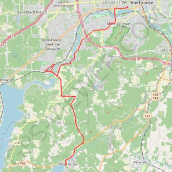
Rando Sherbrooke-North Hatley
VTT. En aller simple entre Sherbrooke et North Hatley. #VTT
- Distance: 24.6 Km
- Elevation gain: 318 m
- Maximum elevation: 320 m
- Elevation loss: 364 m
- Minimum elevation: 161 m
Interactive map
GPS track profile
About this GPS track
Name: Rando Sherbrooke-North Hatley GPS track, route, trail
Start: 83, Rue du Québec, Les Nations, Sherbrooke, Estrie, Québec, J1H 3H2, Canada (45.40009 -71.90481)
End: 72, Rue School, North Hatley, Memphrémagog, Estrie, Québec, J0B 2C0, Canada (45.27435 -71.97392)
Coordinates: 45.27435 -71.99752 45.40009 -71.90481
Other GPS tracks
Click on a GPS track to view route, its statistics and profile.