PR07 PIC
- Distance: 6.2 Km
- Elevation gain: 108 m
- Maximum elevation: 410 m
- Elevation loss: 512 m
- Minimum elevation: 2 m
Interactive map
GPS track profile
About this GPS track
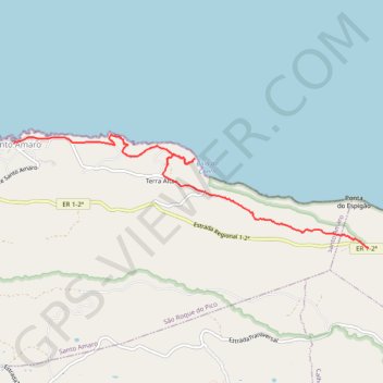
Name: PR07 PIC GPS track, route, trail
End: Santo Amaro, São Roque do Pico, Açores, 9940, Portugal (38.45595 -28.16646)
Coordinates: 38.44525 -28.16646 38.45689 -28.11965
Other GPS tracks
Click on a GPS track to view route, its statistics and profile.