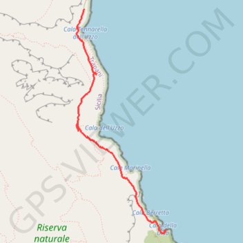
2018-05-09 11:07:54
En aller simple.
- Distance: 3.7 Km
- Elevation gain: 135 m
- Maximum elevation: 92 m
- Elevation loss: 180 m
- Minimum elevation: 3 m
- Moving time: 1 h 11 m
- Moving speed: 3.1 Km/h
- Maximum speed: 23.4 Km/h
- Total time: 1 h 23 m
- Global speed: 2.7 Km/h
- Date: 09/05/18
Interactive map
GPS track profile
About this GPS track
Name: 2018-05-09 11:07:54 GPS track, route, trail
End: Sentiero di collegamento, San Vito Lo Capo, Trapani, Sicile, 91010, Italie (38.09934 12.79857)
Coordinates: 38.09906 12.78661 38.12315 12.79882
Other GPS tracks
Click on a GPS track to view route, its statistics and profile.
Rando risiverva dello zingaro
Italie > Sicile > Trapani > San Vito Lo Capo > Scopello
Randonnée pédestre. En aller simple. #Randonnée
Distance: 5.7 Km • Elevation gain: 237 m • Maximum elevation: 111 m
2018-05-09 14:37:35
Italie > Sicile > Trapani > San Vito Lo Capo
En aller-retour.
Distance: 10.7 Km • Elevation gain: 598 m • Maximum elevation: 173 m
2018-05-09 14:37:35
Italie > Sicile > Trapani > San Vito Lo Capo
En aller-retour.
Distance: 8.2 Km • Elevation gain: 429 m • Maximum elevation: 126 m