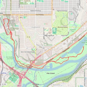
Crosby Farm-Hidden Falls Ride
Loop bike / hike via Old Watergate Marina, Mississippi River, Hidden Falls, Hidden Falls Creek, Upper Lake and Crosby Lake in the Crosby Farm Regional Park and the Uŋčí Makhá Park. #Bike #Hike #Loop #Park #Lake #River #Nature #Forest #Falls
- Distance: 14.2 Km
- Elevation gain: 159 m
- Maximum elevation: 255 m
- Elevation loss: 159 m
- Minimum elevation: 213 m
- Moving time: 55 m 9 s
- Moving speed: 15.5 Km/h
- Maximum speed: 34.7 Km/h
- Total time: 1 h 44 s
- Global speed: 14.1 Km/h
- Date: 13/03/24
Interactive map
GPS track profile
About this GPS track
Name: Crosby Farm-Hidden Falls Ride GPS track, route, trail
Coordinates: 44.89443 -93.19723 44.91615 -93.14733
Other GPS tracks
Click on a GPS track to view route, its statistics and profile.
St Paul Cycling
United States > Minnesota > Ramsey County > Saint Paul
Distance: 39.0 Km • Elevation gain: 292 m • Maximum elevation: 290 m