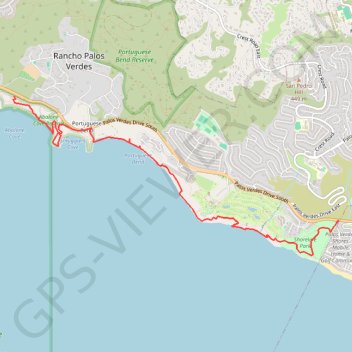
Shoreline Park, Ocean Trails and Abalone Cove
Hike along the Pacific Coast via Shoreline Park, Ocean Trails Reserve and Abalone Cove Reserve. #Hike #Pacific #Ocean #Sea #Coast #Nature #Park #Beach
- Distance: 8.3 Km
- Elevation gain: 320 m
- Maximum elevation: 125 m
- Elevation loss: 390 m
- Minimum elevation: 0 m
- Moving time: 2 h 46 m
- Moving speed: 3.0 Km/h
- Maximum speed: 6.9 Km/h
- Total time: 3 h 36 m
- Global speed: 2.3 Km/h
- Date: 10/02/18
Interactive map
GPS track profile
About this GPS track
Name: Shoreline Park, Ocean Trails and Abalone Cove GPS track, route, trail
Start: East Boundary Trail, Rancho Palos Verdes, California, 90732, United States (33.72744 -118.32974)
Coordinates: 33.72284 -118.38105 33.74370 -118.32974