Le Stromboli
Randonnée pédestre. Depuis Stromboli. #Randonnée
- Distance: 8.7 Km
- Elevation gain: 882 m
- Maximum elevation: 902 m
- Elevation loss: 916 m
- Minimum elevation: 0 m
- Moving time: 3 h 19 m
- Moving speed: 2.6 Km/h
- Maximum speed: 12.8 Km/h
- Total time: 5 h 24 m
- Global speed: 1.6 Km/h
- Date: 21/06/15
Interactive map
GPS track profile
About this GPS track
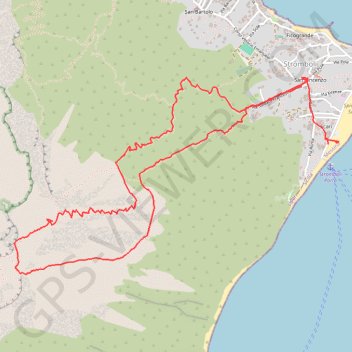
Name: Le Stromboli GPS track, route, trail
End: Via Marina, Ficogrande, Stromboli, Lipari, Messine, Sicile, 98050, Italie (38.79911 15.24025)
Coordinates: 38.79046 15.21370 38.80314 15.24061
Other GPS tracks
Click on a GPS track to view route, its statistics and profile.
Terdav - Eoliennes - J4 - Transfert de Vulcano à Stromboli
Italie > Sicile > Messine > Lipari > Vulcano Porto
Randonnée entre Vulcano Porto et Stromboli. #Randonnée
Distance: 74.1 Km • Elevation gain: 7 m • Maximum elevation: 6 m