2ème randonnée en Guadeloupe
Randonnée pédestre. En aller-retour. #Randonnée #Guadeloupe #Mer #Île
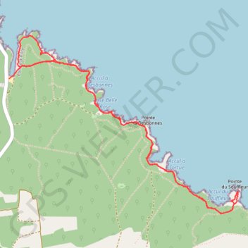
- Distance: 8.6 Km
- Elevation gain: 309 m
- Maximum elevation: 41 m
- Elevation loss: 319 m
- Minimum elevation: 0 m
- Moving time: 2 h 9 m
- Moving speed: 4.0 Km/h
- Maximum speed: 12.1 Km/h
- Total time: 2 h 46 m
- Global speed: 3.1 Km/h
- Date: 13/04/14
Interactive map
GPS track profile
About this GPS track
Name: 2ème randonnée en Guadeloupe GPS track, route, trail
Start: Trace des Falaises, Anse-Bertrand, Pointe-à-Pitre, Guadeloupe, 97121, France (16.48739 -61.43992)
Coordinates: 16.47400 -61.44182 16.49026 -61.42016
Other GPS tracks
Click on a GPS track to view route, its statistics and profile.
Pointe du Souffleur
France > Guadeloupe > Anse-Bertrand
Distance: 7.3 Km • Elevation gain: 242 m • Maximum elevation: 36 m
Trace des Falaises
France > Guadeloupe > Anse-Bertrand
Distance: 4.4 Km • Elevation gain: 35 m • Maximum elevation: 52 m
Pointe du Souffleur
France > Guadeloupe > Anse-Bertrand
Distance: 7.3 Km • Elevation gain: 242 m • Maximum elevation: 36 m