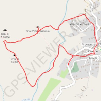
Sentier du patrimoine : Les Orii à Monaccia-d'Aullène
- Distance: 4.6 Km
- Elevation gain: 131 m
- Maximum elevation: 113 m
- Elevation loss: 132 m
- Minimum elevation: 39 m
- Moving time: 1 h 21 m
- Moving speed: 3.4 Km/h
- Maximum speed: 5.0 Km/h
- Total time: 1 h 56 m
- Global speed: 2.4 Km/h
- Date: 13/10/19
Interactive map
GPS track profile
About this GPS track
Name: Sentier du patrimoine : Les Orii à Monaccia-d'Aullène GPS track, route, trail
Coordinates: 41.50818 8.99593 41.51736 9.01181
Other GPS tracks
Click on a GPS track to view route, its statistics and profile.
1 LUCENA - MONTPELLIER
Distance: 2,964.4 Km • Elevation gain: 29,500 m • Maximum elevation: 1,048 m
1 LUCENA - MONTPELLIER
Espagne > Andalousie > Lucena
Distance: 2,964.4 Km • Elevation gain: 29,500 m • Maximum elevation: 1,048 m
Ajaccio - Bastia par le sud
France > Corse > Corse-du-Sud > Ajaccio
Vélo. En aller simple entre Ajaccio et Bastia. #Vélo
Distance: 337.2 Km • Elevation gain: 4,747 m • Maximum elevation: 556 m
TG6ak
France > Corse > Haute-Corse > Bastia
tour de corse vélo de voyage trace en préparation
Distance: 811.0 Km • Elevation gain: 22,311 m • Maximum elevation: 1,478 m