Elbe-Lübeck-Kanal
- Distance: 63.6 Km
- Elevation gain: 307 m
- Maximum elevation: 22 m
- Elevation loss: 313 m
- Minimum elevation: 0 m
- Moving time: 5 h 55 m
- Moving speed: 10.7 Km/h
- Maximum speed: 43.2 Km/h
- Total time: 7 h 43 m
- Global speed: 8.2 Km/h
- Date: 02/05/19
Interactive map
GPS track profile
About this GPS track
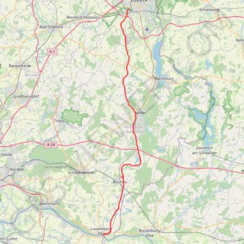
Name: Elbe-Lübeck-Kanal GPS track, route, trail
Coordinates: 53.37034 10.55828 53.84596 10.69192
Other GPS tracks
Click on a GPS track to view route, its statistics and profile.
TET-Germany-Section1-20210518
Germany > Schleswig-Holstein > Ostholstein > Fehmarn > Puttgarden
Distance: 479.4 Km • Elevation gain: 1,685 m • Maximum elevation: 127 m
TET-Germany-Section1-20200619
Allemagne > Schleswig-Holstein > Ostholstein > Fehmarn > Puttgarden
Distance: 479.4 Km • Elevation gain: 1,685 m • Maximum elevation: 127 m
E1_Germany 3
Allemagne > Schleswig-Holstein > Schleswig-Flensburg > Oeversee
Distance: 1,898.0 Km • Elevation gain: 33,186 m • Maximum elevation: 1,446 m