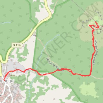
Mont Choungui
Randonnée en aller-retour depuis Choungui. #Randonnée
- Distance: 3.3 Km
- Elevation gain: 241 m
- Maximum elevation: 504 m
- Elevation loss: 241 m
- Minimum elevation: 282 m
- Moving time: 1 h 27 m
- Moving speed: 2.3 Km/h
- Maximum speed: 5.2 Km/h
- Total time: 3 h 15 m
- Global speed: 1.0 Km/h
- Date: 29/09/14
Interactive map
GPS track profile
About this GPS track
Name: Mont Choungui GPS track, route, trail
Start: Rue Tsingo N'Drilé, Choungui, Kani-Kéli, Mayotte, 97625, France (-12.96131 45.12690)
End: Rue Tsingo N'Drilé, Choungui, Kani-Kéli, Mayotte, 97625, France (-12.96133 45.12688)
Coordinates: -12.96133 45.12681 -12.95667 45.13450
Other GPS tracks
Click on a GPS track to view route, its statistics and profile.
Mont Choungui
France > Mayotte > Kani-Kéli > Choungui
Distance: 3.3 Km • Elevation gain: 254 m • Maximum elevation: 504 m