Entre terre et mer à Saint Lô d'Ourville
Interactive map
GPS track profile
About this GPS track
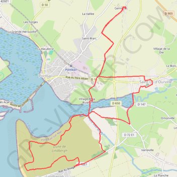
Name: Entre terre et mer à Saint Lô d'Ourville GPS track, route, trail
Coordinates: 49.31721 -1.70616 49.34889 -1.66820
Other GPS tracks
Click on a GPS track to view route, its statistics and profile.
Tour d'Europe
France > Bretagne > Finistère > Concarneau > Landan Creis
Distance: 7,132.9 Km • Elevation gain: 44,603 m • Maximum elevation: 2,433 m
GR 223 Tour du Cotentin (2021)
France > Normandie > Eure > Berville-sur-Mer
Randonnée en Normandie sur le GR 223 autour du Cotentin à travers l'Eure, le Calvados et la Manche de Berville-sur-Mer au Mont-Saint-Michel.
Distance: 650.7 Km • Elevation gain: 6,685 m • Maximum elevation: 149 m
Sentier Cotentin - Cherbourg vers Mont-Saint-Michel
France > Normandie > Manche > La Hague > Urville-Nacqueville > La Rivière
Distance: 231.7 Km • Elevation gain: 2,584 m • Maximum elevation: 128 m
Dimanche 2 juin
France > Normandie > Manche > Périers
Periers - La Haye - Periers
Distance: 112.9 Km • Elevation gain: 733 m • Maximum elevation: 99 m
GR223 - Cherbourg à Coutances
France > Normandie > Manche > Cherbourg-en-Cotentin
Randonnée entre Cherbourg-Octeville et Coutances. #Randonnée
Distance: 201.4 Km • Elevation gain: 2,106 m • Maximum elevation: 138 m
RAF 2022 / 2600 n1 News
France > Hauts-de-France > Pas-de-Calais > Le Touquet-Paris-Plage
Distance: 2,594.8 Km • Elevation gain: 39,725 m • Maximum elevation: 2,766 m
2 - vtt 55km 2024
France > Normandie > Manche > Saint-Sauveur-le-Vicomte > Le Paradis
VTT 55 km
Distance: 57.8 Km • Elevation gain: 651 m • Maximum elevation: 127 m
3 Sainte-Mère Hauteville
France > Normandie > Manche > Sainte-Mère-Église > Richedoux
Parcours initial Sainte-Mère Hauteville le 07/06/2024 à 16H30
Distance: 82.2 Km • Elevation gain: 382 m • Maximum elevation: 55 m
Randonnée de Cherbourg à Portbail par le GR 223
France > Normandie > Manche > Cherbourg-en-Cotentin
Randonnée sur sentier du littoral à travers la Manche de Cherbourg à Portbail via Equeurdreville, Urville-Nacqueville, Hameau aux Fèvres (Greville-Hague), Digulleville, Herqueville, Biville, Les Pieux, Surtainville, Baubigny, Barneville-Carteret et Barneville-Carteret. #Randonnée #GR223 #Normandie #Manche #Mer #Nature
Distance: 110.6 Km • Elevation gain: 2,100 m • Maximum elevation: 131 m
Etape 2 du Raid de l'Archange
France > Normandie > Manche > Carteret > Le Valnotte
De Carteret à Lestre
Distance: 79.8 Km • Elevation gain: 631 m • Maximum elevation: 114 m
Mère Denis
France > Normandie > Manche > Port-Bail-sur-Mer > Portbail > La Hieullerie
22 km
Distance: 22.7 Km • Elevation gain: 217 m • Maximum elevation: 67 m
Itinéraire de Nemours à Nemours
France > Centre-Val de Loire > Loiret > Bromeilles > Bainvilliers
Distance: 1,576.4 Km • Elevation gain: 8,536 m • Maximum elevation: 238 m
TM2024 ET1 Marigny-Barneville-17221486
France > Normandie > Manche > Marigny-Le-Lozon > Marigny > L'Hôtel Acher
Distance: 167.9 Km • Elevation gain: 1,858 m • Maximum elevation: 115 m
TM2024 ET2 Barneville- Sartilly V1-17625469
France > Normandie > Manche > Barneville-Carteret > Le Dessous du Bourg
Distance: 170.8 Km • Elevation gain: 1,724 m • Maximum elevation: 130 m
1 - etape-3-tdn-2024-parcours (1)
France > Normandie > Manche > Coutances
Etape 3 16 mars 2024
Distance: 137.1 Km • Elevation gain: 1,831 m • Maximum elevation: 157 m
TM2024 ET1 Marigny-Barneville-17221486
France > Normandie > Manche > Marigny-Le-Lozon > Marigny > L'Hôtel Acher
Distance: 167.6 Km • Elevation gain: 1,868 m • Maximum elevation: 115 m
1 - gainsbarre
France > Normandie > Manche > Port-Bail-sur-Mer > Portbail > La Hieullerie
Circuit
Distance: 174.2 Km • Elevation gain: 1,039 m • Maximum elevation: 63 m
GR223 De Tourlaville à Portbail (Manche)
France > Normandie > Manche > Cherbourg-en-Cotentin
Randonnée entre Cherbourg-Octeville et Portbail. #Randonnée
Distance: 110.2 Km • Elevation gain: 2,026 m • Maximum elevation: 131 m
TM2024 ET2 Barneville- Sartilly V1-17625469
France > Normandie > Manche > Barneville-Carteret > Le Dessous du Bourg
Distance: 170.8 Km • Elevation gain: 1,724 m • Maximum elevation: 130 m
TM2024 ET2 Barneville - Sartilly V2-17230687
France > Normandie > Manche > Barneville-Carteret > Le Dessous du Bourg
Distance: 158.1 Km • Elevation gain: 1,517 m • Maximum elevation: 130 m
Les chemins de Saint-Michel - Cherbourg - Lessay
France > Normandie > Manche > Cherbourg-en-Cotentin
Randonnée entre Cherbourg-Octeville et Lessay. #Randonnée
Distance: 90.9 Km • Elevation gain: 788 m • Maximum elevation: 164 m
TM2024 ET2 Barneville - Sartilly V2-17230687
France > Normandie > Manche > Barneville-Carteret > Le Dessous du Bourg
Distance: 173.3 Km • Elevation gain: 1,609 m • Maximum elevation: 130 m
Tous les coins du Cotentin-12150732
France > Normandie > Manche > Saint-Floxel
Distance: 317.9 Km • Elevation gain: 3,204 m • Maximum elevation: 168 m
TM2024 ET2 Barneville - Sartilly V2-17230687
France > Normandie > Manche > Barneville-Carteret > Le Dessous du Bourg
Distance: 170.5 Km • Elevation gain: 1,554 m • Maximum elevation: 130 m
TM2024 ET2 Barneville - Sartilly V2-17230687
France > Normandie > Manche > Barneville-Carteret > Le Dessous du Bourg
Distance: 159.9 Km • Elevation gain: 1,520 m • Maximum elevation: 130 m
TM2024 ET2 Barneville - Sartilly V2-17230687
France > Normandie > Manche > Barneville-Carteret > Le Dessous du Bourg
Distance: 159.9 Km • Elevation gain: 1,520 m • Maximum elevation: 130 m
201 Barneville St Lô d'ourville 001 001
France > Normandie > Manche > Carteret > Le Valnotte
Distance: 76.9 Km • Elevation gain: 605 m • Maximum elevation: 114 m
New
France > Normandie > Manche > Port-Bail-sur-Mer > Saint-Lô-d'Ourville > Varreville
Distance: 104.3 Km • Elevation gain: 521 m • Maximum elevation: 46 m
ETAPE 02 Barneville /Torigni V2
France > Normandie > Manche > Barneville-Carteret > Le Dessous du Bourg
Distance: 167.0 Km • Elevation gain: 1,436 m • Maximum elevation: 212 m
ETAPE 02 Barneville /Torigni V2
France > Normandie > Manche > Barneville-Carteret > Le Dessous du Bourg
Distance: 167.0 Km • Elevation gain: 1,436 m • Maximum elevation: 212 m
ETAPE 01 _V4 Yquelon/Barneville
France > Normandie > Manche > Yquelon
Distance: 138.6 Km • Elevation gain: 1,008 m • Maximum elevation: 104 m
ETAPE 02 Barneville /Torigni
France > Normandie > Manche > Barneville-Carteret > Le Dessous du Bourg
Distance: 140.2 Km • Elevation gain: 1,132 m • Maximum elevation: 209 m
ETAPE 02 Barneville /Torigni
France > Normandie > Manche > Barneville-Carteret > Le Dessous du Bourg
Distance: 141.7 Km • Elevation gain: 1,170 m • Maximum elevation: 209 m
ETAPE 01 _V4 Yquelon/Barneville
France > Normandie > Manche > Yquelon
Distance: 138.6 Km • Elevation gain: 1,008 m • Maximum elevation: 104 m
ETAPE 01 _V3 Yquelon/Barneville
France > Normandie > Manche > Yquelon
Distance: 138.5 Km • Elevation gain: 1,009 m • Maximum elevation: 104 m
Yquelon_Barneville_V3
France > Normandie > Manche > Yquelon
Distance: 162.2 Km • Elevation gain: 1,252 m • Maximum elevation: 104 m
ETAPE 01 Yquelon/Barneville
France > Normandie > Manche > Yquelon
Distance: 144.6 Km • Elevation gain: 1,144 m • Maximum elevation: 134 m
Yquelon_Barneville_V4
France > Normandie > Manche > Yquelon
Distance: 162.0 Km • Elevation gain: 1,250 m • Maximum elevation: 104 m
ETAPE 02 Barneville /Torigni V2
France > Normandie > Manche > Barneville-Carteret > Le Dessous du Bourg
Distance: 167.0 Km • Elevation gain: 1,436 m • Maximum elevation: 212 m
Evening Mar 27th
France > Normandie > Manche > Cherbourg-en-Cotentin
Distance: 151.7 Km • Elevation gain: 1,304 m • Maximum elevation: 153 m