Five Lakes Basin
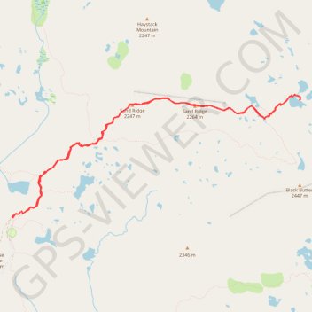
Hike to Five Lakes Basin via Grouse Ridge Trail, Glacier Lake Trail and Sand Ridge Trail in the Tahoe National Forest. #Hike #Mountain #Lake #Nature #Forest
- Distance: 12.8 Km
- Elevation gain: 459 m
- Maximum elevation: 2,284 m
- Elevation loss: 458 m
- Minimum elevation: 2,115 m
- Moving time: 4 h 23 m
- Moving speed: 2.9 Km/h
- Maximum speed: 5.2 Km/h
- Total time: 1 d 8 m
- Global speed: 0.5 Km/h
- Date: 06/09/14
Interactive map
GPS track profile
About this GPS track
Name: Five Lakes Basin GPS track, route, trail
Coordinates: 39.39066 -120.60971 39.40788 -120.55743
Other GPS tracks
Click on a GPS track to view route, its statistics and profile.
Lindsey Lake to Five Lakes Basin Loop
United States > California > Nevada County
Loop hike between Lindsey Lake and Five Lakes Basin via Carr-Lindsey Road, Middle Lindsey Dam, Culbertson Lake, Lindsey Lake Trail, Lower Rock Lake, Rock Lake, Crooked Lake Trail, Penner Lake, Crooked Lakes, Island Lake, Round Lake Trail, Long Lake, Round Lake, Milk Lake, Grouse Ridge Trail, Sand Ridge Trail, Sand Ridge, Five Lakes…
Distance: 37.7 Km • Elevation gain: 1,044 m • Maximum elevation: 2,314 m
Chester - Walker
États-Unis d'Amérique > Californie > Plumas County > Chester
Vélo. En aller simple entre Chester et Walker. #Vélo
Distance: 383.8 Km • Elevation gain: 6,088 m • Maximum elevation: 2,541 m